Prof. Yin investigates the geology of other worlds

A topographic false-color map of Mars including some of the largest volcanoes and the largest canyon in the solar system. Image Credit: NASA/JPL/Caltech/Arizona

Few people can claim that their children learned to walk in the forests of Yosemite National Park.  Professor An Yin, who has spent much of his 26 years at UCLA conducting fieldwork in Tibet, the Himalayas, and California, can.  Having spent his graduate career investigating remote areas of Glacier National Park, Yin’s mountaineering experience equipped him for the challenging Asian fieldwork and tectonic research that earned him the Donath Medal from the Geological Society of America. “It was a frontier in an area that was not explored before, despite it being on Earth,” said Yin. “Knowing almost nothing about this large area, I tried to make a synthesis.”  Nowadays, Yin spends less time in Tibet and the Himalayas, making only two trips a year, usually to drop off graduate students to conduct their own fieldwork.  Instead, he has directed his interest toward the fledgling field of research known as planetary geology.

In 2008, Yin began applying his Earth geology expertise to landscapes he observed on other planets. “Having limited data to create a tectonic story in large areas of Asia gave me the know-how to explore planet-related problems,” Yin said. “The process turns out to be quite similar.” In his early days of Tibetan research Yin used satellite images to estimate locations of faults before going into the field; similarly, he uses satellite images to understand planetary geology from afar.  Images today, however, provide more clues about the geology.  “High-resolution images have revolutionized mapping and geologic interpretation,” said Yin. “We still can’t determine composition, but we can say for certain how much and in what manner a feature is offset from its original position.”

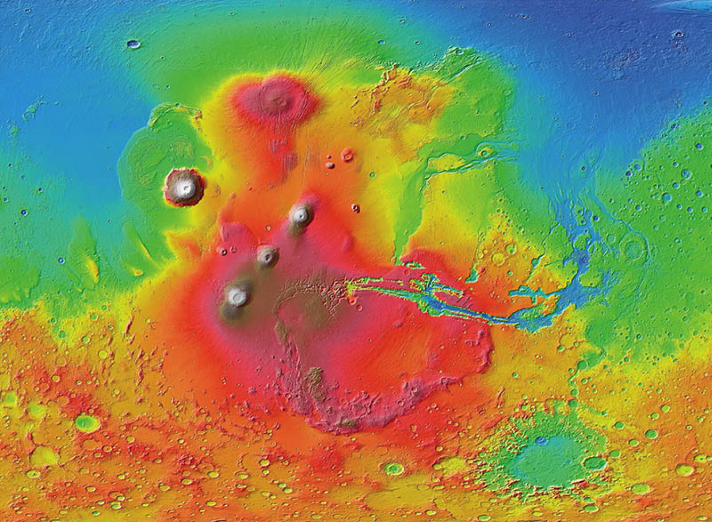
To explain the features he observes on Mars, Yin has developed a theory that invokes a one-plate tectonic system.  Unlike Earth, which has 15 major tectonic plates that move continuously and are responsible for forming mountains and oceans, Mars has only one plate that moves very slowly.  Moving at a pace 1000 times slower than those on Earth, Mars’ tectonic plate produces  plate-boundary features like volcanoes and faults that materialize in a relatively small area and grow very large.  Maps of Mars show that almost all its prominent features are confined to just one-third of the planet.  Among these features are the colossal Tharsis Montes, three volcanoes so large they could fit 32 of Earth’s three-mile-high Andean volcanoes into the volume they occupy.

Although Mars’ features are grander, they share many characteristics with Earth’s terrain.  This observation led Yin to contemplate the underlying processes that create the two planets’ surfaces.  For not only Mars, but for many planetary bodies, the differences in these processes may be the result of their individual “evolutionary paths,” said Yin.

Piecing together the story of how a planet’s geology has changed over time requires Yin to use all the resources at his disposal. “The problem with planetary geology is that you see a static image,” he said, “the history is harder to show.”  One way of revealing the history is by observing it.  In Yin’s laboratory, he and his graduate students design sandbox experiments to reveal how faults, mountains, and valleys develop.  While these experiments are intended to mimic natural conditions, they do not represent the exact history of any process, and act more as a guide to help determine whether their basic assumptions are correct.

From these experiments, Yin has determined that the histories of Mars and Earth are quite similar, differing only in their rates of evolution.  “Mars is smaller and has less heat, so the driving engine is not as powerful as Earth’s,” said Yin.  Although Mars and Earth appear to be quite similar, other planetary bodies may have very dissimilar evolutionary paths.

Yin’s newest foray into planetary science involves Enceladus, an icy moon of Saturn.  He interprets the famous “Tiger Stripes” that periodically eject water vapor from its south pole as a product of the movement of the moon’s icy shell, and prefers to call them “Horsetails,” after a Himalayan feature they so closely mimic.  While Yin can decipher portions of Enceladus’ history from its surface features, it remains unclear whether there is a global or localized ocean beneath the icy surface. “This is an actively debated subject,” said Yin, “but for now I can only tell the story of what happened.”

From the otherworldly geology he’s studied thus far, Yin has learned that “the planetary world is something that defies common sense in many respects.  We have an idea of how a planet should develop and what it should look like, and we find exception after exception after exception.” Yin hopes that his continued interdisciplinary approach to planetary geology will result in observing “overlapping parts of commonality” between planets that could reveal more about planetary evolution as a whole.

Watch a video profile of An Yin here.  Learn more about his research here.

Graduate student Jessica Watkins studies landslides on Mars

For third-year UCLA graduate student Jessica Watkins, the “big picture goal” has always been to travel to space as an astronaut.  To achieve her dream meant intense physical training (she was part of Stanford’s 2008 international collegiate rugby championship team) and earning a Ph.D. in a research area relevant to space. Beginning her education as a mechanical engineer, she soon realized it wasn’t for her.  Turning to a course bulletin for inspiration, she found classes about planets and atmospheres in Stanford’s Geological and Environmental Sciences department that would prove to suit her well.

Presently, Watkins works with her advisor, UCLA Professor An Yin, to understand massive landslides in Mars’ Valles Marineris, a network of canyons the size of the continental United States.  Using images and data from NASA’s Mars Reconnaissance Orbiter and satellite images of Earth for comparison, she attempts to determine whether the cause of Martian landslides is tectonic activity, flowing water, glaciers, or something else.  Accordingly, Watkins is trying to determine if any of the minerals in her landslides are hydrated, or wet.  Although she is not studying the astrobiological aspects of the minerals, she said her work is “one small study that could tell us a lot,” including information about the habitability of Mars.

Watkins also examines landslides up close to understand how to best interpret images of Mars’ landslides. During a recent field investigation of a Mars-like landslide in Death Valley National Park, Watkins was surprised that some of her preliminary image interpretations were incorrect. “There are many things about other planets that we might not be able to truly understand just from images,” she said. “Being able to walk around and get your hands on it really makes a difference.”

That’s what drew Watkins to planetary geology.  “UCLA merges geology and planetary science really well,” she said.  “I can use my Earth geology background to study other planets.” This summer, Watkins will collaborate with Mars Science Laboratory (MSL) scientists at the Jet Propulsion Laboratory (JPL) in Pasadena, California in hopes of improving our understanding of Mars’ surface.  In retrospect, Watkins realizes she has always been interested in Mars. “My earliest memory of being interested in Mars was in fifth grade,” she said. “We had to make illustrated books – I wrote mine on Marty the Martian.”

Watch a video profile of Jessica Watkins here.  Learn more about her research here.

Top scientists debate whether life could survive on Mars

Artist's concept of the Phoenix lander on the surface of Mars. In 2008, scientists were surprised to find that the substance perchlorate was present in the Martian soil. Photo credit: NASA/JPL-Caltech

More than 50 of the world’s top Mars scientists gathered in Royce Hall last week to discuss whether life could survive on the red planet. Three dozen talks over two days covered topics ranging widely from the current liquid water activity on Mars to NASA’s planetary protection policies.

“The habitability of Mars is a pressing issue because we plan to send humans there in the next century,” said David Paige, a UCLA professor of Earth and space sciences and a co-organizer of the conference, held Feb. 4-5. “To do that in a responsible way, we should take into account that there could be an indigenous biosphere on Mars, and do our best to predict what would happen to any terrestrial organisms we might bring with us.”

Life is almost everywhere we look on Earth, but that’s not true for inhospitable Mars. Andrew Schuerger, an astrobiologist from the University of Florida and speaker at the conference, went so far as to list 17 separate environmental hazards that could freeze, irradiate or otherwise disrupt microbial life on the surface of Mars. Topping the list: powerful, microbe-frying, ultraviolet light from the sun; sub-zero temperatures; and a thin, oxygen-less atmosphere with pressure levels 100 times lower than those found on Earth.

Nonetheless, Schuerger and his colleagues have made it their mission to find the hardiest bacteria surviving in the harshest environments on Earth and to determine whether the tiny microorganisms could grow in Mars-like conditions. His search was rewarded with the discovery of several hypobarophiles, microorganisms that can grow in extremely low-pressure and low-temperature environments. While some of these single-celled survivors hail from the Canadian Arctic or the depths of Siberia, others live closer to home: Schuerger was particularly surprised to find hypobarophiles in a sample he took of human saliva.

Yet even the sturdiest of the hypobarophiles would shrivel without a stable source of liquid water, said Schuerger. While liquid water may be hard to come by on the Martian surface, there is plenty of evidence that water exists beneath the surface, according to Alfred McEwen, a planetary geologist from the University of Arizona.

First discovered from images taken by the Mars Reconnaissance Orbiter in 2011, Recurring Slope Lineae (RSL) are dark streaks that slowly creep down sun-facing crater rims and canyon walls during the Martian spring and summer and then fade in winter. The flow of liquid water, mixed with Martian salts several centimeters beneath the planet’s surface, may be responsible for tracing the finger-like patterns, though the source of the water is still unknown.

A color-enhanced image of the inside rim of Newton Crater on Mars. The dark streaks, called Recurring Slope Lineae (RSL), may represent current subsurface liquid water activity. The image was taken by an instrument onboard the Mars Reconnaissance Orbiter. NASA/JPL/University of Arizona

“The exact mechanism is not well understood,” said McEwen. “Given the seasonality and temperature dependence, we think a volatile must be involved, and briny water is the best candidate.”

While the formation of RSL may look remarkably like streaming water on Earth, McEwen is quick to put aside the notion, emphasizing that, on Mars, the trickle of briny water takes weeks to flow downhill and behaves more like “maple syrup slowly oozing down the slope.”

While liquid water on Mars may be subsurface and salty, one of the largest questions the conference dealt with was the role of perchlorate, a high-energy molecule toxic to most kinds of life.

In 1976, twin Viking spacecraft landed on the surface of Mars and analyzed the composition of Martian soil for signs of past or present life. Viking found only a single organic molecule, which the science team dismissed as a remnant of cleaning products used on Earth prior to launch. However, in 2008, an experiment onboard the Phoenix lander surprised scientists when it indicated the presence of perchlorate.

“Perchlorate is a double-edged sword,” said Paige. “It is a reactive molecule that destroys organic molecules, yet we find a variety of organisms on Earth that, in fact, use it to survive.”

If perchlorate, a common component in pyrotechnics and rocket fuel, was present in those early Viking samples, it may have completely destroyed any interesting organics the experiment was meant to measure. A reanalysis of the Viking results published more than 30 years later revealed that the single organic molecule the experiment detected was not the result of Earth-based contaminants as originally suspected, but instead the predicted byproduct of a perchlorate reaction.

“This could be a very exciting explanation for the Viking results that showed no organic molecules except one that could easily be residue from the combustion of perchlorate and organics,” said Paige. “This opens up a whole new set of possibilities that just weren’t there before the perchlorate molecule was discovered on Mars.”

Strong among these possibilities is the fact that perchlorates can draw atmospheric water vapor into liquid form. Liquid water produced in such a way on Mars could potentially provide hydration for microbes capable of surviving in the presence of the reactive perchlorate molecules. Just as important, when perchlorate mixes with water on Mars, it forms salty brine that freezes at a much lower temperature than pure water, which extends the range of potentially habitable conditions on Mars.

Solving the puzzle of whether life could survive in the harsh and varied environments of Mars requires a community of scientists from across many disciplines, said Paige.

“Many different types of scientists are involved, from researchers who study orbital images to biologists who grow microorganisms in petri dishes, and everyone in between,” he said. “To get such a diverse community together was a lot of fun.”

The conference, sponsored by the UCLA Institute for Planets and Exoplanets (iPLEX), the NASA Astrobiology Institute and the UK Centre for Astrobiology, is the first iPLEX meeting to be open for virtual participation. Nearly 50 participants watched the conference online, asking speakers questions via webchat. Nine talks were given remotely by speakers located as far away as the United Kingdom, Hungary and Russia.

iPLEX aims to advance research into planetary systems around the sun and other stars by facilitating interdepartmental collaboration. It is a joint venture bridging the interests of researchers in the departments of Earth and Space Sciences, Physics and Astronomy, and Atmospheric and Oceanic Sciences.

___________________________________________________________________

All conference talks were recorded and archived online; they can be streamed for free by the public from the conference website.

UCLA scientist discovers plate tectonics on Mars

For years, many scientists had thought that plate tectonics existed nowhere in our solar system but on Earth. Now, a UCLA scientist has discovered that the geological phenomenon, which involves the movement of huge crustal plates beneath a planet’s surface, also exists on Mars.

“Mars is at a primitive stage of plate tectonics. It gives us a glimpse of how the early Earth may have looked and may help us understand how plate tectonics began on Earth,” said An Yin, a UCLA professor of Earth and space sciences and the sole author of the new research.

Read full UCLA Newsroom article

An Yin demonstrates his method for studying plate tectonics on Mars:
http://www.youtube.com/watch?v=3ahLnxD3GIo

The Grandest Canyon: New insight into Mars’ Valles Marineris

Global topographic map of Mars and location of Valles Marineris.

By Ivy S. Carpenter

A giant gash scars the surface of Mars.  Known as Valles Marineris, it is one of the largest and most recognizable topographic features in our solar system.  Boasting a whopping 4000-km length and a depth ranging from 10 – 15 km, it easily dwarfs Earth’s Grand Canyon (which is a piddling 2 km deep). But despite the distinction of being the longest trough system in the solar system, its origin and formation remain enigmatic.

In a new study selected as Editor’s Choice in the 2012 June 29th issue of Science and to be published in Lithosphere, UCLA’s Professor An Yin suggests that the current structure of the solar system’s ‘grandest canyon’ is a result of left-lateral transtensional faulting, similar to that found in Earth’s Dead Sea fault system.

A three-dimensional structural model for southern Valles Marineris. Notice that the fault zone consists of multiple faults, and the trough bounded on one side by a normal fault and the other side by a strike slip fault. Circles with dots indicate motion toward the viewer, circles with an X indicate motion away from the viewer.

In his model, transtensional deformation (a result of mixed lateral and extensional movement) occurs as a zone of both strike-slip (horizontal ground motion) and normal (vertical motion) faults.  The normal faults allow for the subsidence and subsequent infill of a deep trough area, while strike-slip faults offset these sediments and underlying rock.

In a geological mapping tour-de-force, Yin used high-resolution data from NASA’s Mars Reconnaissance Orbiter and Mars Odyssey spacecraft to define the shapes, orientations, and cross-cutting relationships of surface structures such as landslides, erosion, impact features, strata, marker beds and folds in the southern end of the trough.

The results of the mapping effort show impressive trough-parallel left-slip offsets of 150-160 km throughout the Ius-Melas-Coprates fault zone.  Offsets are seen clearly where numerous landslide deposits have been displaced sideways by ground motions (see image below).   At a larger-scale, Yin identified a continuous, long (>2000 km) and narrow (<50 km) strike-slip zone with >100 km in total slip that appears strikingly similar to the undisputed plate boundary of the Earth’s Dead Sea fault zone.  Some local trough-bounding faults may still be active, as they are seen to cut recent surface deposits and landslides.

(A) Image showing two landslides whose channels and fans have been offset by left-lateral strike slip motion. (B) Restored landslide postions after matching up the edges of the channels with their fans.

An alternate interpretation made recently by Jeffrey Andrews-Hannah of the Colorado School of Mines proposes that Marineris is a subsidence feature that formed as a result of the uplift of the nearby Tharsis bulge (see Andrews-Hanna, J.C. 2012., JGR, 117, E06002 at www.agu.org/pubs). However,  Andrews-Hannah’s model does not easily account for the physical evidence of horizontal as well as vertical motion in the trough.  The scientific debate has already been highlighted by several sources even before Yin’s paper has been published.

Yin’s study raises the fascinating question of why a planet that has supposedly not had plate tectonics for the past 4 billion years  should show a feature that looks convincingly like a plate boundary.  Vast areas of Valles Marineris, not to mention the other 143,998,500 square kilometers of Mars’ surface, remain imperfectly explored. Accordingly, there remains huge potential for what geological observations may tell us about the structure of this and other planets in the future.

To read Professor An Yin’s full paper, download it here, see the August 2012 issue of Lithosphere or visit http://lithosphere.gsapubs.org/.

View the Editor’s Choice article from the June 29th, 2012 issue of Science, “Debating the Grandest Canyon”.

View the UK’s Earth-Pages coverage of the debate, “A mighty sag or a big wrench for Mars“.

Watch Professor Yin discuss some of his current research in his iPLEX Planetary Profile:

http://www.youtube.com/watch?v=rlsgQz3p1WM